Theme: Spaces and Places
Back to Top
|
 |
|
The Mobility Space Report: What the Street!?
|
Science |
|
Described as a "puzzle of urban mobility space," What the Street!? explores how major cities around the world allocate their mobile space. Using OpenStreetMap software, data scientists and designers Michael Szell and Stephan Bogner creatively graphed parts of major cities' infrastructure. Currently, more than 20 cities are available, including Beijing, Chicago, Rome, and Johannesburg. To select a city, click on the down arrow next to "Who owns" on the project's landing page. From there, visitors can scroll through the interactive data visualization project to see how much of the city is covered by parking lots, compared to rail lines or bike paths. Additionally, clicking on a color-coded data piece brings up its real-life location via Google maps. Szell and Bogner created the project during their residencies with moovel lab (now move lab), a think-space focused on "the future of mobility." Readers interested in the design process behind What the Street!? may want to read the creators' corresponding blog post (linked on the About page). Here, readers will learn more about how and why the project was launched. [EMB] |
|


|
|
 |
|
Kiruna Forever
|
Social studies |
|
"How do you move a city?" Kiruna Forever, an exhibition physically located at The Swedish Centre for Architecture and Design (ArkDes) and virtually available to viewers worldwide, explores this question. Kiruna is a city in Sweden undergoing "one of the biggest urban transformation projects in modern history ... [as it] is being relocated by three kilometres due to the expansion of the mine around which Kiruna was built." Many of its residents, especially the Indigenous residents, must relocate, and historic landmarks are being destroyed or moved. Led by curator Carlos Minguez Carrasco, Kiruna Forever investigates these major changes and their impacts. Viewers will see work from architects, urban planners, and artists, learn more about the history of Kiruna and its residents, and be challenged to think about limits on natural resources and the loss of residents' identity. The video also features other guests, and readers should note that some guests converse in Swedish. The full list of presenter, architect, and artist credits is available below the video. Scrolling to the bottom of the page, readers will find additional multimedia resources from ArtDes (in a mixture of English and Swedish). [EMB] |
|


|
|
 |
|
 |
|
 |
|
Pacific Coast Architecture Database
|
Arts |
|
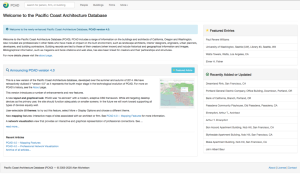
Architecture aficionados will delight in the Pacific Coast Architecture Database (PCAD). Alan Michelson, head of the Built Environments Library at the University of Washington-Seattle, first launched the site in 2002 as "CAD" (California Architecture Database). In 2005, a career move to the University of Washington allowed him to expand the project to include Oregon and Washington. PCAD documents information on impressive architecture and architects, including history, geography, and "impact[s] on the built environment." The query bar at the top of the site welcomes users to "search for a person, firm, or building." There are also pages dedicated to each of these three categories. On the People page, users will find a list of more than 8,000 architects, designers, and similar figures. The Buildings page highlights more than 20,000 structures (listed by address). Clicking on an address reveals additional information such as maps, images, and historical details. Finally, the Firms page provides an alphabetized index of more than 6,000 architecture and design firms. Additionally, the More tab provides articles, exhibitions, pictures, and access to the PCAD Blog (last updated in 2015). [EMB] |
|


|
|


